Image


Blizzard conditions in the south give way to a historic Arctic freeze statewide
A powerful winter storm system is sweeping across Minnesota, delivering a rare and dangerous one-two punch: blizzard conditions across southern and southwestern counties, followed by an incoming Arctic air mass that meteorologists describe as the coldest to grip the region in years. Based on National Weather Service bulletins and local transportation and emergency updates issued January 21, 2026, the threat is both immediate and prolonged, with impacts expected to last through the weekend.

Through 7:00 p.m. CST this evening, a Blizzard Warning remains in effect for several south-central and southwestern counties, including Redwood, Brown, Watonwan, Blue Earth, Martin, Faribault, and Freeborn.
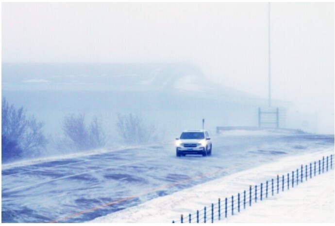
While new snowfall totals are relatively modest, generally 1 to 2 inches, the danger comes from powerful winds gusting up to 55 miles per hour. Those winds are lifting existing snow from open fields and roadways, producing ground blizzard conditions with near-zero visibility, particularly along rural highways and exposed stretches of roadway.
Transportation officials and meteorologists have warned that these conditions can deteriorate rapidly, turning routine travel into a life-threatening situation within minutes. The Minnesota Department of Transportation has advised against travel in affected areas, especially during the evening commute, as drifting snow and whiteout conditions make roads nearly impossible to navigate.
Several school districts across southern and western Minnesota opted to close early on Wednesday, aiming to get students home before the most intense winds arrived.
As the snow and wind begin to ease, a much colder threat takes center stage.
The National Weather Service has issued Extreme Cold Warnings for northern Minnesota beginning Thursday evening, with dangerously cold conditions expanding southward into central Minnesota and the Twin Cities by early Friday. This alert category, which replaced traditional Wind Chill Warnings, is reserved for the most severe cold events.

Forecasts indicate:
Meteorologists note that this Arctic outbreak is expected to be the coldest air mass to affect Minnesota since 2019, with its persistence posing a major concern. Much of the state is projected to remain below zero for 60 to 80 consecutive hours, extending through Sunday.
The severity of the storm has already begun to disrupt transportation across Minnesota and beyond.
With subzero temperatures expected to persist for days, officials are emphasizing community care alongside individual preparedness. Residents are encouraged to check on elderly neighbors, ensure pets are brought indoors, and conserve heat where possible to reduce strain on household heating systems.
This storm is not defined by a single moment of impact but by its duration and intensity. Blizzard conditions may pass within hours, but the Arctic cold settling in behind them will test Minnesota’s infrastructure, emergency systems, and neighbor-to-neighbor vigilance through the weekend.
For real-time updates, residents are advised to monitor National Weather Service statements, MnDOT travel advisories, and local emergency notifications as conditions continue to evolve.


Sunny, with a high of 88 and low of 64 degrees. Sunny during the morning, patchy rain nearby overnight.