Image

MINNESOTA — January 24, 2026 — Minnesota is enduring one of its most severe cold outbreaks in years as a historic Arctic air mass tightens its grip on the state, pushing temperatures to dangerous extremes and disrupting daily life from the Twin Cities to the Canadian border.
What began earlier this week as a powerful winter storm to the south has evolved into a prolonged and life-threatening cold event, driven by a rare atmospheric configuration known as a stretched polar vortex. Meteorologists say the current outbreak represents the coldest air mass to settle over Minnesota since 2019, with impacts expected to linger through the weekend and potentially beyond.
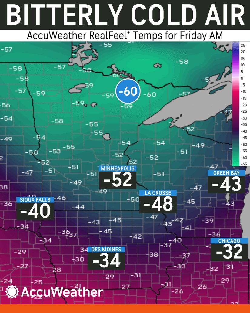
By early Friday morning, January 23, overnight lows in the Twin Cities plunged to 21 degrees below zero, marking the metro’s coldest reading in roughly seven years. In northern Minnesota, air temperatures fell even further, bottoming out near 38 below zero in some communities.
Wind compounded the danger. Persistent northwest gusts combined with the subzero air to produce wind chills as low as 63 below zero, including readings reported near Grand Marais along the North Shore. Across much of the state, “feels like” temperatures have consistently ranged between 40 and 55 below zero, levels at which frostbite can occur rapidly.
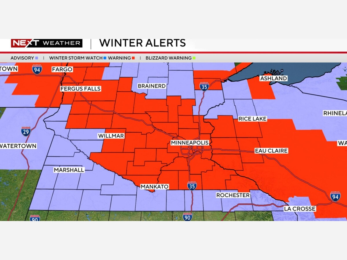
The National Weather Service has kept Extreme Cold Warnings in effect across large portions of Minnesota, warning that exposed skin can freeze in as little as five to ten minutes under these conditions. Officials have stressed that even brief outdoor exposure can be dangerous, particularly for children, older adults, and anyone without adequate winter clothing.
The cold has forced widespread adjustments across Minnesota.
Schools and universities: Dozens of school districts, including St. Paul, Anoka-Hennepin, and Duluth, canceled classes or shifted to e-learning on Friday due to the hazardous conditions. The University of Minnesota reduced operations across its Twin Cities, Duluth, and Rochester campuses, citing safety concerns for students and staff.
Events: The Saint Paul Winter Carnival, a signature midwinter celebration, postponed its kickoff and canceled several outdoor events, including the popular ice bar. Organizers said temperatures had dropped below thresholds considered safe for both attendees and workers.
Transportation: Extreme cold has also strained regional travel. Amtrak canceled Borealis and Empire Builder services through Saturday, pointing to the combined effects of recent blizzard conditions and the mechanical risks posed by Arctic temperatures that can damage rail equipment.
Meteorologists point to a complex chain of atmospheric events behind the current deep freeze.
At the center of the explanation is the polar vortex, a large pool of frigid air that normally remains concentrated near the North Pole during winter. In January 2026, that system has not collapsed entirely, but it has stretched into an elongated shape, allowing one lobe of Arctic air to plunge deep into the central United States.
Forecasters describe Duluth as a kind of epicenter for this displaced lobe. With the vortex core anchored near northeastern Minnesota, a direct corridor has opened for bitterly cold air to flow south and west across the state.
A key trigger was a Sudden Stratospheric Warming (SSW) event earlier this month, when temperatures high in the stratosphere rose sharply and disrupted the strong winds that normally keep the polar vortex stable. Once weakened, the vortex became prone to wobbling and elongation, setting the stage for the current outbreak.
Scientists note that events like this highlight a growing paradox in a warming world. While global average temperatures continue to rise, rapid warming in the Arctic is believed to be weakening the jet stream, making it more prone to large north-south swings. Those undulations can increase the likelihood of extreme cold snaps in the mid-latitudes, even as winters overall grow shorter and less predictable.
Short-term forecasts suggest little immediate relief. Daytime highs through the weekend are expected to remain near or below zero across much of Minnesota, with overnight lows staying firmly in the double digits below zero. Some moderation is possible early next week, but temperatures are still forecast to remain well below seasonal norms.
Longer-range outlooks are drawing particular attention. Some forecast models indicate the polar vortex could become even more unstable in early February. A more complete breakdown of the circulation would risk keeping the “Arctic door” open, allowing repeated surges of extreme cold to spill south into the Upper Midwest.
Emergency managers and weather officials continue to urge Minnesotans to take the cold seriously:
As this Arctic outbreak grinds on, the message from forecasters is clear: Minnesota knows winter, but this is a reminder of how quickly cold can turn from uncomfortable to dangerous.


Sunny, with a high of 74 and low of 50 degrees. Sunny during the morning, clear overnight.