Image

Twin Cities, MN
After weeks of stubborn midwinter cold, a notable atmospheric shift on Sunday, February 1, 2026, brought a rare moment of seasonal relief across large swaths of central North America. From the Upper Midwest to the eastern slopes of the Canadian Rockies, southerly winds and a dominant ridge of high pressure combined to push temperatures well above recent norms, offering a brief but striking contrast to January’s prolonged deep freeze.
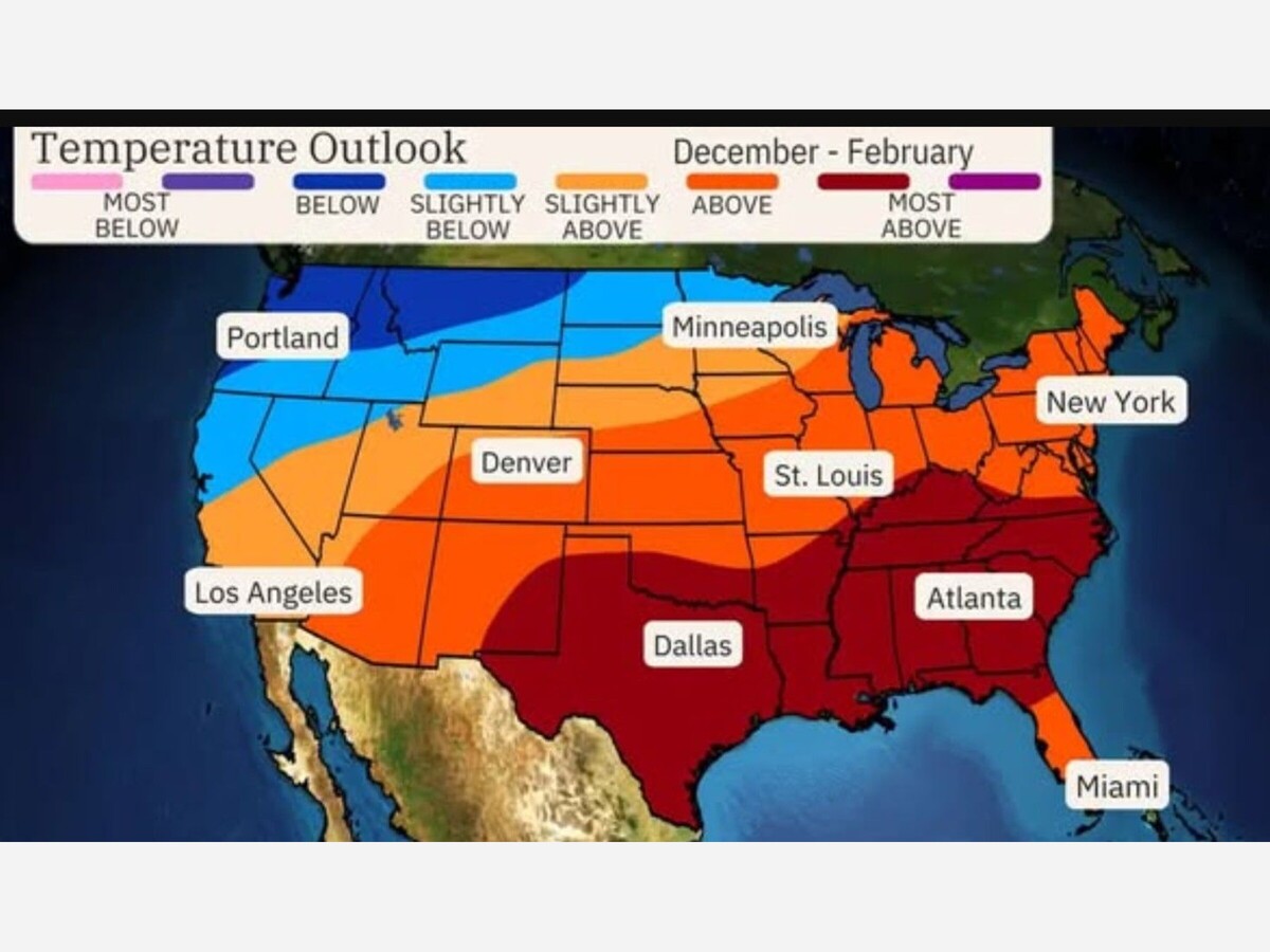
In Minnesota, the change was subtle but significant. Forecast guidance from the National Weather Service Twin Cities indicated afternoon highs climbing into the upper 20s Fahrenheit, the first time temperatures have edged above average since mid January. The moderation was driven by a shift in surface winds out of the south, allowing milder air to spill northward ahead of a passing cold front.
For context, the long term climate normal for early February at Minneapolis St. Paul International Airport, based on the 1991 to 2020 averages compiled by the Minnesota Department of Natural Resources, sits in the mid 20s. Readings approaching 30 degrees therefore register as modestly above normal, even if they still feel firmly wintry.
Meteorologists cautioned that the warmth is short lived. The same forecast discussions point to colder air returning early in the week, with daytime highs falling back into the teens by Monday and Tuesday as the front clears the region. Still, the brief thaw marked a psychological milestone after weeks of below average temperatures that had dominated much of January.
Far more dramatic was the warmup unfolding simultaneously in Western Canada. In Calgary and across southern Alberta, a powerful ridge of high pressure settled over the region, triggering classic Chinook conditions along the eastern slopes of the Rockies.
According to guidance from Environment and Climate Change Canada and The Weather Network, temperatures on February 1 surged into the low double digits Celsius, roughly 10 to 11 degrees, translating to the low 50s Fahrenheit. That stands in sharp contrast to the region’s typical early February daytime highs near minus 2 Celsius.
The catalyst was persistent southerly and southwesterly flow, with winds sustained between 20 and 40 kilometers per hour and higher gusts in exposed areas. These winds funneled warm, dry air downslope over the Rockies, rapidly eroding the cold air that had been entrenched since mid January. The result was a temperature anomaly of roughly 12 to 15 degrees Celsius above seasonal norms, marking the most sustained stretch of above average warmth in weeks.
Unlike the fleeting moderation in Minnesota, forecasters in Alberta emphasized that the pattern was likely to hold. The high pressure ridge was expected to remain locked in place for several days, allowing temperatures to climb even higher by midweek. Some southern Alberta communities could see highs approaching 15 to 20 degrees Celsius by Wednesday, levels more typical of April than early February.
The warmth has immediate consequences. Snowpack across urban and rural areas is rapidly diminishing, and officials have flagged concerns about an intense freeze thaw cycle. As daytime melting gives way to overnight refreezing near the zero degree mark, roads and sidewalks can become dangerously icy, even as afternoons feel almost springlike.
Together, the events underscore how a single large scale atmospheric pattern can manifest very differently across regions. In Minnesota, the southerly flow translated into a brief return to near normal winter temperatures before colder air reasserts itself. In southern Alberta, the same general circulation unlocked Chinook winds capable of delivering record challenging warmth and reshaping the landscape in a matter of days.
For residents on both sides of the border, the message from forecasters is similar. Enjoy the respite, but do not mistake it for a true seasonal turn. Winter, meteorologists stress, is far from finished.

Sunny, with a high of 73 and low of 37 degrees. Sunny in the morning, partly cloudy for the afternoon and evening, clear overnight.