Image

Minnesota is preparing for a two-part weather pattern that will bring rain, heavy snow, and strong winds to the region, followed by another potentially significant snowstorm over the weekend.
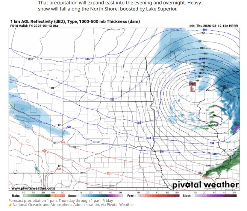
Forecasters say the first system will move through the state Thursday into early Friday, producing rain across southern Minnesota and accumulating snow across northern parts of the state, especially along the North Shore of Lake Superior.
Meteorologists with the National Weather Service say the incoming system will briefly pull warmer air into the region ahead of the storm, pushing temperatures above average before colder air returns early next week.
Temperatures on Thursday will vary significantly across the state.
Forecast highs include:
These temperature differences will determine whether communities experience rain or snow.
Snow showers are expected to develop across northwestern Minnesota by midday Thursday, while rain showers move into southern Minnesota later in the afternoon. As the storm strengthens and moves east Thursday evening, precipitation will expand across much of the state.
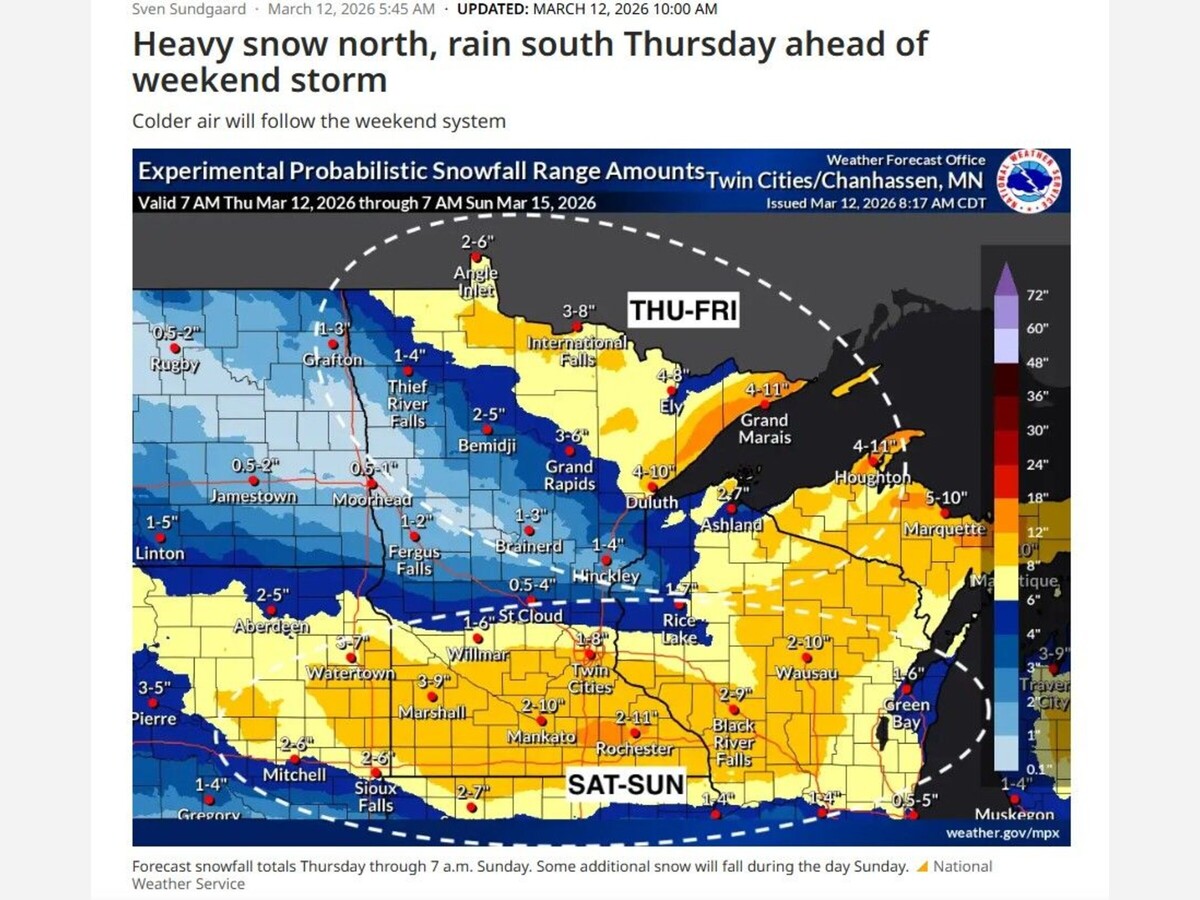
Northern Minnesota will see the greatest snowfall from the system.
Several inches of snow are expected across much of the northern portion of the state, with the heaviest snowfall likely along the North Shore, where the influence of Lake Superior can intensify snow through a process known as lake enhancement.
When colder air moves over the comparatively warmer waters of Lake Superior, additional moisture is pulled into the atmosphere, often producing heavier snowfall in nearby coastal communities.
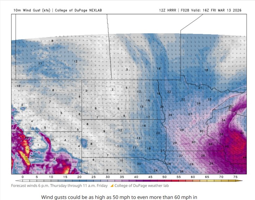
In addition to snow and rain, strong winds are expected to develop late Thursday into early Friday.
Wind gusts could reach 50 miles per hour across western Minnesota, with isolated gusts potentially exceeding 60 miles per hour overnight.
Due to the expected conditions, the National Weather Service has issued several alerts, including:
These conditions could create hazardous travel due to blowing snow and sharply reduced visibility, particularly in areas where heavy snowfall combines with strong winds.
Meteorologists are also closely monitoring another winter storm expected to impact the Upper Midwest this weekend.
Forecast models currently suggest the system will bring significant snowfall somewhere from central Minnesota through northern Iowa and into Wisconsin between Saturday and Sunday.
As of Thursday morning, many models indicate southeastern Minnesota could receive the heaviest snowfall, though forecasters caution the exact track may shift before the system arrives.
Communities across southern Minnesota, northern Iowa, and central and southern Wisconsin should prepare for the possibility of snowfall totals exceeding six inches, with some locations potentially seeing more than a foot of snow depending on the final storm path.
After the weekend storm passes, a colder air mass will settle over the region.
High temperatures Monday are expected to reach only the teens and 20s across much of Minnesota, nearly 20 degrees below average for mid-March.
Overnight lows Monday night could fall below zero in northern Minnesota, while the Twin Cities area may see single-digit temperatures into early Tuesday morning.
Despite the early-week cold, long-range forecasts suggest another shift in the weather pattern.
Temperatures may climb quickly late next week, with parts of Minnesota potentially seeing spring-like highs in the 50s and even 60s once again.
The rapid swings between winter and spring conditions are typical for late-season storm patterns across the Upper Midwest, where strong systems can produce dramatic temperature shifts within a matter of days.
MinneapoliMedia
Community. Culture. Civic Life.


Sunny, with a high of 67 and low of 42 degrees. Sunny in the morning, partly cloudy during the afternoon and evening, clear overnight.