Image

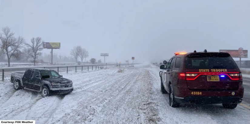
The Anoka County Sheriff’s Office issued a public safety advisory ahead of the weekend storm, reminding drivers that heavy snow, strong winds, and rapidly changing road conditions could make travel dangerous from Saturday evening, March 14, through Monday morning, March 16.
Officials say the message is simple but critical: slow down, turn on headlights, prepare vehicles properly, and carry emergency supplies in case drivers become stranded.
The warning comes as meteorologists track a powerful storm system sweeping across the Upper Midwest that is expected to bring heavy snowfall and strong winds to large portions of Minnesota.
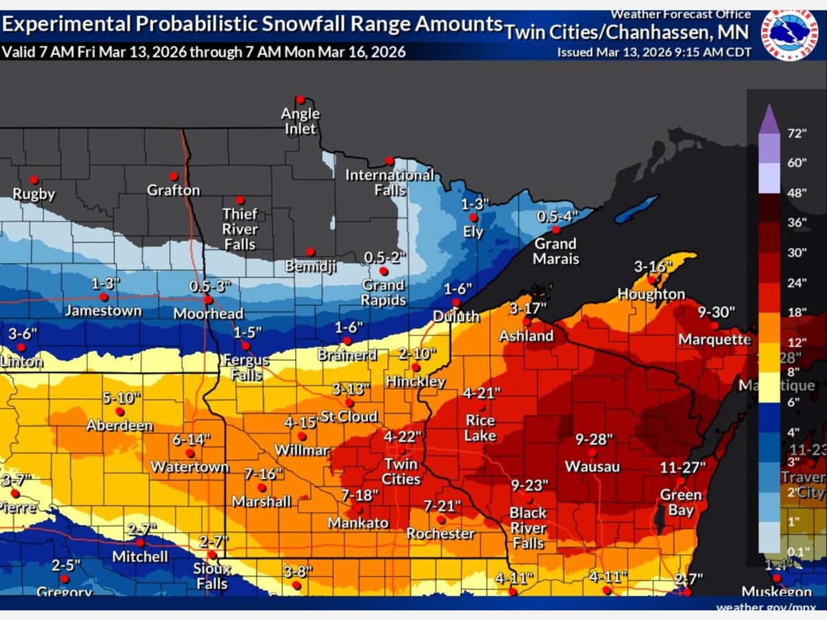
According to the National Weather Service, a Winter Storm Warning remains in effect for the Twin Cities metropolitan region, including Anoka County, as forecasters expect widespread heavy snow and deteriorating travel conditions through the weekend.
Meteorologists say the storm will arrive in phases.
Light precipitation may begin Saturday afternoon before intensifying late Saturday evening. The most severe portion of the storm is expected between 7:00 p.m. Saturday and early Sunday morning, when snowfall rates could reach 1 to 2 inches per hour.
Current forecasts suggest widespread totals of 10 to 16 inches of snow across much of Anoka County, with localized bands potentially reaching 18 inches or more if the storm stalls over the region.
Strong winds will further complicate conditions.
Forecasters expect northeast winds shifting northwest Sunday with gusts reaching 40 to 45 miles per hour, which could produce blowing and drifting snow and sharply reduce visibility.
While the Twin Cities metro remains under a Winter Storm Warning rather than a Blizzard Warning, meteorologists note that periods of blizzard-like conditions are possible, especially Sunday as winds strengthen and snow continues to fall.
Under federal weather criteria, a Blizzard Warning requires winds of at least 35 mph combined with falling or blowing snow reducing visibility below one-quarter mile for three hours or more.
Even without the formal designation, forecasters warn travel could become “very difficult to impossible” during the height of the storm, particularly overnight Saturday into Sunday.
In anticipation of deteriorating road conditions, the Anoka County Sheriff’s Office is encouraging residents to think ahead before traveling.
“Slow down and turn your headlights on,” the agency advised drivers.
Authorities also recommend that every vehicle traveling during winter storms carry basic emergency supplies in case drivers become stranded.
Recommended vehicle items include:
• Snow shovel, broom, and ice scraper
• Abrasive material such as sand or kitty litter to provide traction if stuck
• Jumper cables and a flashlight
• Emergency warning devices such as flares or reflective markers
• A first aid kit
• Blankets or extra clothing for warmth
• A cell phone with charger
• Drinking water, food, and necessary medications
Emergency preparedness guidance from organizations such as the American Red Cross and FEMA also recommends including high-energy non-perishable food such as granola bars, a portable power bank for phones, waterproof gloves, hats, and emergency Mylar blankets.
These supplies can become critical if motorists are delayed by crashes, whiteout conditions, or impassable roads.
Authorities also stressed the importance of guarding against carbon monoxide poisoning, one of the most dangerous risks during winter travel emergencies.
Carbon monoxide is colorless, odorless, and tasteless, making it difficult to detect without warning devices.
When vehicles become stuck in deep snow, exhaust pipes can easily become blocked. If the engine continues to run, exhaust gases may be forced back into the vehicle cabin.
The sheriff’s office recommends motorists:
• Ensure the exhaust pipe remains clear of snow
• Run the vehicle only intermittently to stay warm
• Never run the engine continuously with windows fully closed
Symptoms of carbon monoxide poisoning can include headache, dizziness, nausea, confusion, and shortness of breath. Anyone experiencing these symptoms should immediately shut off the engine, open windows, and move to fresh air if it is safe to do so.
Even before the storm reaches peak intensity, several local road projects could complicate travel in Anoka County.
One of the most significant closures currently in effect is County State Aid Highway 7 (Rum River Boulevard) in the city of Oak Grove.
The roadway is closed between 218th Avenue and 219th Avenue for the replacement of the Seelye Brook Bridge. The closure began March 9 and is expected to continue through June, with traffic detoured to Minnesota Highway 47.
Other construction zones across the county could become particularly hazardous during heavy snowfall.
Along Highway 10 in Coon Rapids, traffic remains in a three-lane configuration between Hanson Boulevard and Round Lake Boulevard due to ongoing noise wall construction. Reduced shoulder space in that corridor may complicate snow removal efforts and increase congestion.
In Fridley, the 44th Avenue Northeast bridge over the BNSF Railway remains temporarily open while minor work continues, and drivers may encounter uneven surfaces.
Meanwhile, final work continues around the Ramsey Gateway interchange near U.S. Highway 10 and Highway 169, where signage and construction barriers remain in place.
Officials warn that drivers navigating these areas during the storm should allow additional travel time.
Transportation officials recommend that drivers check conditions before traveling during severe weather events.
The Minnesota 511 system, operated by the Minnesota Department of Transportation, provides live road condition reports, plow tracking, traffic cameras, and closure alerts across the state.
Local authorities also encourage drivers to monitor updates from the Anoka County Highway Department, which provides information on county road conditions and maintenance operations.
If motorists become stalled during severe winter weather, safety experts recommend remaining inside the vehicle rather than attempting to walk in poor visibility or extreme cold.
Drivers should:
• Stay with the vehicle and avoid overexertion
• Mark the vehicle with bright cloth or reflective materials
• Turn on the interior dome light when possible to improve visibility
Emergency responders say these simple steps can help rescuers locate stranded motorists more quickly.
Anyone needing emergency assistance should call 911 immediately.
Late-season winter storms are not uncommon in Minnesota, but meteorologists say the combination of heavy snowfall, high winds, and prolonged duration makes this system particularly concerning.
As the storm approaches, law enforcement officials are emphasizing preparation, patience, and caution on the road.
In Minnesota winters, they say, the difference between a safe trip and a dangerous one often comes down to a few simple decisions made before the journey begins.
MinneapoliMedia
Community. Culture. Civic Life.


Sunny, with a high of 67 and low of 42 degrees. Sunny in the morning, partly cloudy during the afternoon and evening, clear overnight.