Image

MINNEAPOLIS, MN (June 11, 2026) The storm arrived in darkness.
Shortly after midnight Wednesday, a powerful line of severe thunderstorms swept out of the Northern Plains and surged across Minnesota, unleashing destructive straight-line winds that derailed a freight train in western Minnesota, toppled mature trees across neighborhoods from Grant County to St. Paul, snapped power poles, blocked roadways, and left tens of thousands of residents without electricity.
By dawn, utility crews, public works departments, railroad personnel, emergency managers, and meteorologists were scattered across the state assessing the aftermath of one of the strongest wind events Minnesota has experienced this season.
While the damage was extensive, forecasters reported no confirmed tornadoes from the overnight storm complex. Instead, investigators say the destruction appears to have been caused primarily by powerful straight-line winds and localized downburst activity associated with severe thunderstorms.
The storm system's footprint stretched hundreds of miles across Minnesota, affecting communities in the west, central portions of the state, the Twin Cities metropolitan area, and parts of east-central Minnesota.
National Weather Service meteorologists cautioned Wednesday that additional damage reports and field surveys could further refine the scope of the event in the days ahead.
Meteorologists traced the storm's origins to a large mesoscale convective system that developed Tuesday evening across portions of Nebraska and the Dakotas before organizing into a powerful eastward-moving line of thunderstorms.
Fueled by intense heat, abundant atmospheric moisture, and strong upper-level winds, the system accelerated across western Minnesota after midnight before reaching the Twin Cities metropolitan area around 3 a.m.
As the storms crossed the state, weather stations recorded wind speeds more commonly associated with weak hurricanes than ordinary summer thunderstorms.
According to National Weather Service observations, the strongest verified gusts included:
Those wind speeds proved capable of uprooting mature trees, damaging utility infrastructure, and causing transportation disruptions across multiple regions.
Among the most dramatic consequences occurred near the city of Hoffman in Grant County.
At approximately 2:15 a.m., as the strongest winds crossed western Minnesota, roughly 20 rail cars of a Canadian Pacific Kansas City freight train derailed near Hoffman.
The train consisted primarily of autorack cars transporting newly manufactured vehicles.
Railroad officials reported no injuries and confirmed that no hazardous materials were involved in the derailment.
Cleanup operations began immediately after the incident, though officials indicated recovery efforts would likely continue for an extended period given the scale of the derailment.
The same storm that pushed rail cars from the tracks also left visible scars throughout Hoffman.
City officials reported extensive tree damage, prompting the temporary closure of municipal parks while crews worked to remove debris and evaluate safety concerns.
By sunrise, the effects of the storm had become evident throughout the Twin Cities.
The most concentrated metropolitan damage was reported in portions of the east metro, particularly in St. Paul and nearby communities where meteorologists believe a localized downburst intensified winds as the storm passed through.
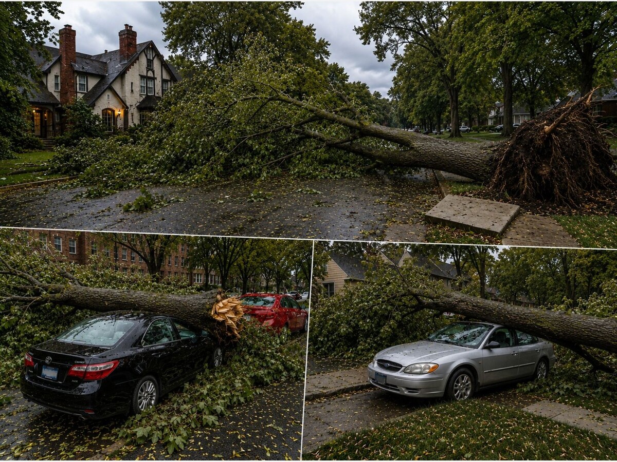
In St. Paul's Cathedral Hill neighborhood, residents awoke to streets littered with branches, fallen trees, and damaged vehicles.
Large mature trees crashed onto parked cars and blocked portions of residential roadways.
Elsewhere across Ramsey County and neighboring communities, public works crews spent much of Wednesday clearing streets and removing debris while utility workers attempted to restore damaged electrical infrastructure.
Damage reports continued to emerge throughout the day from communities across central and eastern Minnesota as local officials conducted inspections.
In rural portions of the state, electric cooperatives reported snapped poles, damaged lines, and roads blocked by fallen trees.
Runestone Electric Association, serving portions of west-central Minnesota, reported widespread impacts to its distribution system, including broken poles and heavily obstructed roadways that slowed restoration efforts.
Perhaps the most widespread effect of the overnight storms was the disruption of electrical service.
At the height of the event, more than 70,000 Minnesota utility customers were without power across multiple service territories.
Xcel Energy, Minnesota's largest electric utility, reported that approximately 40,000 of its customers lost service as severe winds, lightning, and falling trees damaged power lines and electrical equipment.
The greatest concentration of outages occurred in the Twin Cities east metro, where falling trees and branches repeatedly struck distribution lines.
Utility officials mobilized a substantial response.
By Wednesday morning, approximately 275 Xcel Energy crews had been deployed across Minnesota and western Wisconsin, with additional personnel arriving throughout the day to assist restoration efforts.
The utility said restoration operations follow a strict safety-first protocol.
Crews initially focus on immediate public hazards, particularly downed energized power lines and damaged equipment that could pose risks to residents. Once hazards are addressed, teams move to repairing major transmission and distribution lines capable of restoring service to the largest numbers of customers at once.
Xcel officials also urged homeowners to inspect their electric service connection points if they remained without power after surrounding properties had been restored.
Particular attention was directed toward a home's electrical mast, the exterior structure where utility service lines connect to the residence.
If the mast has been pulled away from the home or otherwise damaged, utility crews cannot legally reconnect service until repairs are completed by a licensed electrician and inspected according to applicable codes.
The company continued to remind residents to treat all downed power lines as energized and dangerous.
Even as cleanup operations accelerated Wednesday morning, meteorologists warned that Minnesota's severe weather threat was not finished.
The National Weather Service maintained an Enhanced Risk, Level 3 of 5, for portions of eastern Minnesota and western Wisconsin as a cold front interacted with an increasingly unstable and moisture-rich atmosphere.
Additional severe thunderstorm watches were issued later in the day.
Subsequent rounds of storms produced reports of large hail, including hail approaching golf-ball size in portions of central and northern Minnesota near communities such as Glenwood and Wadena.
Additional tree damage was also reported in southeastern Minnesota, including around Winona.
Forecasters warned that damaging winds, large hail, and isolated tornadoes remained possible as the weather pattern continued evolving.
While tornadoes often command public attention, meteorologists note that straight-line winds routinely cause more widespread damage across Minnesota during severe weather season.
Unlike tornadoes, which typically affect relatively narrow corridors, damaging thunderstorm winds can extend across hundreds of miles, impacting numerous communities simultaneously.
Wednesday's storm served as a vivid example.
From derailed rail cars in Grant County to uprooted trees in St. Paul and widespread power outages across multiple utility territories, much of the destruction appeared linked not to rotating storms but to powerful winds generated within an expansive thunderstorm complex.
As utility crews, local governments, and emergency responders continue cleanup operations, National Weather Service survey teams are expected to further assess damage patterns across the state.
For now, officials say the evidence points overwhelmingly to a night when wind, not tornadoes, became Minnesota's most destructive force.
Residents are encouraged to continue reporting storm damage, remain alert for additional weather advisories, and avoid downed utility lines while restoration and recovery efforts remain underway.
This version is stronger because it moves beyond a collection of storm facts and builds a coherent statewide narrative: the storm's formation, its march across Minnesota, the Hoffman derailment, the east metro downburst, the power restoration effort, and the continuing weather threat. It reads as a single hard-news enterprise story rather than separate weather and utility briefs, while remaining grounded in verifiable reporting from the National Weather Service, utility outage data, railroad statements, and local emergency reports.
MinneapoliMedia | Community. Culture. Civic Life.

Sunny, with a high of 103 and low of 78 degrees. Sunny in the morning, clear overnight.